Waituna Lagoon Loop Track
Alerts
Check the DOC website for current alerts and conditions before you go. This site gets current alert info from DOC, but is not an official source of information.
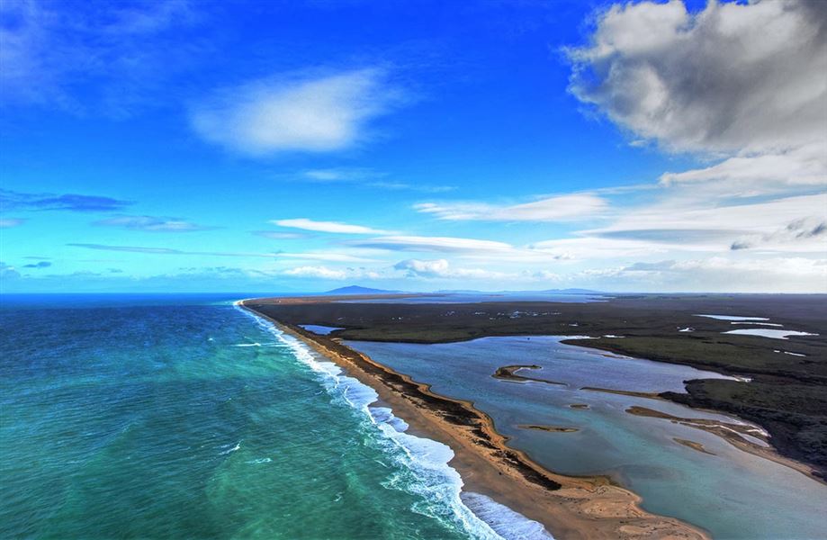
You can stroll the boardwalk, walk through wetland tarns or along the spectacular white quartz beach to the outlet of Waituna Lagoon. Waituna is a Ramsar site internationally recognised as a place of importance for birdlife.
Elevation
Cover mapped summer 2023/24.
Description
The first part of the Waituna Lagoon Loop Track is a wheelchair-friendly boardwalk leading to a lookout.
Boardwalk
Track category: Easy access short walk, suitable for wheelchairs
Time: 10 min return
Distance: 500 m return
The boardwalk winds through low-growing manuka and shrubs, emerging at a viewing shelter that overlooks Waituna Lagoon. Interpretation panels in the shelter provide a wealth of information on the area and its fascinating inhabitants.
The lagoon is periodically open to the sea and its brackish waters are an important habitat for wildfowl, native fish and trout. The viewing platform is a good spot for viewing wildlife.
There is a toilet and picnic table at the carpark at the start of the boardwalk.
Waituna Lagoon Loop Track
Track category: Walking track
Time: 1-1.5 hr return
Distance: 5 km loop track
The track starts on the boardwalk. The first intersection onto the loop track is approximately 50 m from the start of the boardwalk at the carpark.
The loop track is easy walking on both boardwalk and gravel through manuka wetland and past bog tarns.
There are great interpretation panels and rest stops along the way. Listen carefully for fernbirds. This loop track links onto the boardwalk and the viewing platform and will then lead you back to the carpark.
Waituna Lagoon beach access
You can also access the spectacular, white quartz beach off Waituna Lagoon Road. There is no track but you can walk along the beach. The entire walk is 4-5 hr return (9 km one way) from the eastern end of Waituna Lagoon to Waituna Lagoon opening site
The beach walk begins with a gentle climb over a loose gravel bank. Once on the beach walking is easy and can be as long (or short) as you wish.
Don't take vehicles onto the gravel as the gravel is deep and you will get stuck.The gravel is thick and may be sloping and difficult to walk on. Be aware of tides and sea conditions. The gravel beach area is quite steep in places and is exposed.
The Waituna Lagoon is sometimes opened to the sea and the lagoon becomes tidal. You will only be able to walk on the beach up to the site where the lagoon is opened to the sea.
Getting there
Waituna Lagoon is situated 40 km south east from Invercargill at the end of Waghorns Road. Access to the walking track is off the Southern Scenic Route via Waituna Lagoon Road and then Waghorn Road.
Boat ramp access is at two locations: Moffat Road and the corner of Waituna Lagoon Road with Waghorn Road. Waituna Lagoon may not be very deep and may also be tidal so be aware of channels for boat access.
Know before you go
- Waituna Lagoon is situated on the southern coast of Southland. Be prepared for exposed weather conditions.
- The lagoon is sometimes open to the sea so be aware that it may be tidal which can limit both boat and foot access to the lagoon opening site.
- If accessing the coastal beach area the surf can make the beach quite steep and narrow. The beach is not recommended for vehicle access.
- No camping.
- Do not light any fires when visiting the wetland or lagoon. Even though by nature wetlands are wet they burn very easily. In the past fires have swept through hundreds of hectares of the wetland and decades later the vegetation still has not recovered.
Weather
Forecast at the start of the track